
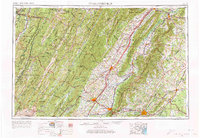
1956 Map of Charlottesville
USGS Topo · Published 1966This historical map portrays the area of Charlottesville in 1956, primarily covering Albemarle County as well as portions of West Virginia. Featuring a scale of 1:250000, this map provides a highly detailed snapshot of the terrain, roads, buildings, counties, and historical landmarks in the Charlottesville region at the time. Published in 1966, it is one of 4 known editions of this map due to revisions or reprints.
Find a feature on this map
74 named features on this map. Tap any name to fly to it.
Don’t see what you’re looking for? This feature index may not catch every label — zoom into the map to look around manually.
Map Details
Editions of this 1956 Charlottesville Map
4 editions found
Historical Maps of Egypt Bend Estates Through Time
36 maps found

1929 Covesville
Albemarle County, VA

1931 University
Albemarle County, VA

1935 Charlottesville
Albemarle County, VA

1935 Covesville
Albemarle County, VA

1935 University
Albemarle County, VA

1939 Charlottesville
Albemarle County, VA

1945 Covesville
Albemarle County, VA

1949 Charlottesville
Albemarle County, VA

1949 Charlottesville
Albemarle County, VA

1956 Charlottesville
Albemarle County, VA

1964 Charlottesville East
Albemarle County, VA

1964 Charlottesville West
Albemarle County, VA

1964 Waynesboro East
Albemarle County, VA

1965 Browns Cove
Albemarle County, VA

1967 Alberene
Albemarle County, VA

1967 Covesville
Albemarle County, VA

1967 Simeon
Albemarle County, VA

1972 Charlottesville East
Albemarle County, VA

1972 Charlottesville West
Albemarle County, VA

1972 Waynesboro East
Albemarle County, VA

1973 Charlottesville East
Albemarle County, VA

1973 Charlottesville West
Albemarle County, VA

1973 Waynesboro East
Albemarle County, VA

1977 Browns Cove
Albemarle County, VA

1977 Charlottesville East
Albemarle County, VA

1977 Charlottesville West
Albemarle County, VA

1977 Waynesboro East
Albemarle County, VA

1979 Alberene
Albemarle County, VA

1979 Covesville
Albemarle County, VA

1979 Simeon
Albemarle County, VA

1986 Charlottesville
Albemarle County, VA

1997 Browns Cove
Albemarle County, VA

1997 Charlottesville East
Albemarle County, VA

1997 Charlottesville West
Albemarle County, VA

1997 Waynesboro East
Albemarle County, VA

1999 Covesville
Albemarle County, VA