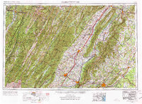
1956 Map of Charlottesville
USGS Topo · Published 1977About this map
The Blue Ridge Mountains and the Shenandoah Mountains dominate this mid-century portrait of Central Virginia and the Potomac Highlands. The valley floor is defined by the three forks of the Shenandoah River and the bustling corridor of Us 11, connecting key regional centers like Harrisonburg, Staunton, and Waynesboro. To the east, the city of Charlottesville sits at the foot of the mountains, while the heights are preserved within Shenandoah National Park and the winding Skyline Drive.
Find a feature on this map
159 named features on this map. Tap any name to fly to it.
Don’t see what you’re looking for? This feature index may not catch every label — zoom into the map to look around manually.
Map Details
Editions of this 1956 Charlottesville Map
4 editions found

Other maps of this area

1884 · Harpers Ferry
USGS Topo · 1:125,000

1886 · St. George
USGS Topo · 1:125,000

1887 · Spottsylvania
USGS Topo · 1:125,000

1887 · Lewisburg
USGS Topo · 1:125,000

1889 · Beverly
USGS Topo · 1:125,000

1890 · Goochland
USGS Topo · 1:125,000

1891 · Harpers Ferry
USGS Topo · 1:125,000

1891 · Palmyra
USGS Topo · 1:125,000

1891 · Lewisburg
USGS Topo · 1:125,000

1891 · Huntersville
USGS Topo · 1:125,000