1964 Map of Charlottesville East
USGS Topo · Published 1965About this map
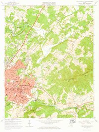
Monticello sits prominently on a ridge overlooking the Rivanna River during this mid-1960s survey of Albemarle County. The landscape is a mix of the developing city and older agricultural foundations, notably marked by the planned expansion of the South Fork Rivanna River Reservoir. Blue hatching on the map indicates the specific areas destined for submersion behind the South Fork Rivanna River Dam, illustrating a significant transformation of the local hydrology. Within the urban core of Charlottesville, the historic Vinegar Hill neighborhood and institutional landmarks like the Blue Ridge Sanatorium are clearly defined. The transition of transportation is evident in the presence of the Southern Railroad alongside the Old Southern Railroad Grade. Educational and civic life are represented through numerous mapped sites, including the Burley High Sch and Walker Jr High Sch, alongside numerous family and church burial grounds such as Michie Tavern Cem and Griffin Cem.
Find a feature on this map
89 named features on this map. Tap any name to fly to it.
Don’t see what you’re looking for? This feature index may not catch every label — zoom into the map to look around manually.
Map Details
Editions of this 1964 Charlottesville East Map
2 editions found

Other maps of this area

1891 · Palmyra
USGS Topo · 1:125,000

1892 · Buckingham
USGS Topo · 1:125,000

1892 · Gordonsville
USGS Topo · 1:125,000

1892 · Harrisonburg
USGS Topo · 1:125,000

1895 · Palmyra
USGS Topo · 1:125,000

1897 · Palmyra
USGS Topo · 1:125,000

1929 · Covesville
USGS Topo · 1:62,500

1931 · University
USGS Topo · 1:62,500

1935 · Charlottesville
USGS Topo · 1:62,500

1935 · Charlottesville And Vicinity
USGS Topo · 1:31,680