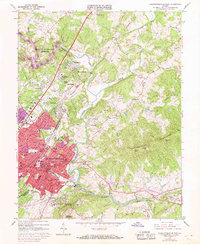
1964 Map of Charlottesville East
USGS Topo · Published 1968About this map
Carters Mountain and the Southwestern Mountains define the topography east of the city, where the Rivanna River carves its way through the landscape. This mid-1960s survey, with updates from 1968, illustrates the northward expansion of Charlottesville as suburban neighborhoods like Northfields and Woodbrook emerge alongside older rural sites. To the southeast, the historic legacy of the area is centered at Monticello Cem and the Jefferson Tomb, while the transportation network is anchored by the Southern Railroad and the Chesapeake and Ohio River. The map documents a community in transition, balancing its deep-seated history at Shadwell and Milton with the modern utility of the South Fork Rivanna River Reservoir and the Blue Ridge Sanatorium. Local landmarks such as the Martha Jefferson Hospital and numerous neighborhood schools like Lane High Sch are clearly visible within the urbanizing core.
Find a feature on this map
89 named features on this map. Tap any name to fly to it.
Don’t see what you’re looking for? This feature index may not catch every label — zoom into the map to look around manually.
Map Details
Editions of this 1964 Charlottesville East Map
2 editions found
Other maps of this area

1891 · Palmyra
USGS Topo · 1:125,000

1892 · Buckingham
USGS Topo · 1:125,000

1892 · Gordonsville
USGS Topo · 1:125,000

1892 · Harrisonburg
USGS Topo · 1:125,000

1895 · Palmyra
USGS Topo · 1:125,000

1897 · Palmyra
USGS Topo · 1:125,000

1929 · Covesville
USGS Topo · 1:62,500

1931 · University
USGS Topo · 1:62,500

1935 · Charlottesville
USGS Topo · 1:62,500

1935 · Charlottesville And Vicinity
USGS Topo · 1:31,680