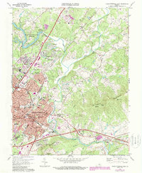
1973 Map of Charlottesville East
USGS Topo · Published 1987About this map
Charlottesville and the surrounding Albemarle County landscape are captured during a period of suburban expansion and historical preservation. The city's core is densely detailed, showing the City Courthouse, City Hall, and Martha Jefferson Hospital amidst a growing network of residential neighborhoods like Berkeley and Wakefield. Outside the city limits, the map traces the legacy of the Third President, specifically the Jefferson Tomb and Monticello Cem on the southern slopes.
Find a feature on this map
85 named features on this map. Tap any name to fly to it.
Don’t see what you’re looking for? This feature index may not catch every label — zoom into the map to look around manually.
Map Details
Editions of this 1973 Charlottesville East Map
3 editions found
Other maps of this area

1891 · Palmyra
USGS Topo · 1:125,000

1892 · Buckingham
USGS Topo · 1:125,000

1892 · Gordonsville
USGS Topo · 1:125,000

1892 · Harrisonburg
USGS Topo · 1:125,000

1895 · Palmyra
USGS Topo · 1:125,000

1897 · Palmyra
USGS Topo · 1:125,000

1929 · Covesville
USGS Topo · 1:62,500

1931 · University
USGS Topo · 1:62,500

1935 · Charlottesville
USGS Topo · 1:62,500

1935 · Charlottesville And Vicinity
USGS Topo · 1:31,680