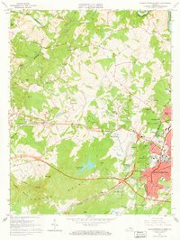
1964 Map of Charlottesville West
USGS Topo · Published 1966About this map
The Ragged Mountains dominate the southern landscape of this mid-1960s survey, rising above the western edges of Charlottesville. This era captures a period of suburban expansion into the foothills, evidenced by the development of neighborhoods like Bellair, Ednam Forest, and Canterbury Hills. The geographic heart of the map is defined by the Chesapeake and Ohio and Southern railroads, which converge near the city center and the university grounds. Cultural landmarks of the period are prominently visible, including the Farmington Country Club, the McCormick Observatory, and Scott Stadium. Water resources are a central theme, with the recently created S Fk Rivanna River Reservoir and the Charlottesville Reservoir providing critical infrastructure for the growing community. Farther west, older rural settlements such as Millington and Owensville maintain their character along the Moormans River and Mechums River.
Find a feature on this map
67 named features on this map. Tap any name to fly to it.
Don’t see what you’re looking for? This feature index may not catch every label — zoom into the map to look around manually.
Map Details
Editions of this 1964 Charlottesville West Map
2 editions found
Other maps of this area

1891 · Palmyra
USGS Topo · 1:125,000

1892 · Buckingham
USGS Topo · 1:125,000

1892 · Gordonsville
USGS Topo · 1:125,000

1892 · Harrisonburg
USGS Topo · 1:125,000

1895 · Palmyra
USGS Topo · 1:125,000

1897 · Palmyra
USGS Topo · 1:125,000

1929 · Covesville
USGS Topo · 1:62,500

1931 · University
USGS Topo · 1:62,500

1935 · Charlottesville
USGS Topo · 1:62,500

1935 · Charlottesville And Vicinity
USGS Topo · 1:31,680