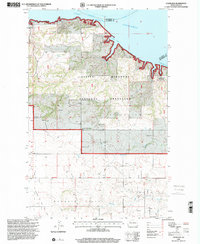
1997 Map of Charlson
USGS Topo · Published 2001About this map
Lake Sakakawea and the Missouri River define the northern boundary of this McKenzie County landscape, where the waters of Phelps Bay meet the shoreline of the Antelope Creek State Game Management Area. This late-1990s revision reveals a rugged, multi-use environment within the Little Missouri National Grassland. The map illustrates the region's ranching heritage and industrial presence, featuring the Charlson Oil and Gas Field and family holdings such as the O and C Froholm Ranch and Hagen Ranch.
Find a feature on this map
22 named features on this map. Tap any name to fly to it.
Don’t see what you’re looking for? This feature index may not catch every label — zoom into the map to look around manually.
Map Details
Editions of this 1997 Charlson Map
This is the sole edition of this map. No revisions or reprints were ever made.
Other maps of this area

1953 · Williston
USGS Topo · 1:250,000

1953 · Watford City
USGS Topo · 1:250,000

1957 · Williston
USGS Topo · 1:250,000

1957 · Watford City
USGS Topo · 1:250,000

1965 · Keene
USGS Topo · 1:24,000

1965 · Charlson
USGS Topo · 1:24,000

1965 · Blue Buttes
USGS Topo · 1:24,000

1965 · Charlson SW
USGS Topo · 1:24,000

1965 · Charlson NE
USGS Topo · 1:24,000

1965 · Charlson NW
USGS Topo · 1:24,000