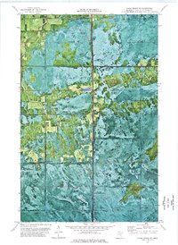
1973 Map of Chase Brook NE
USGS Topo · Published 1976About this map
The Red Lake Indian Reservation encompasses nearly the entire landscape of this 1970s orthophotomap, revealing a northern wilderness defined by dense forest cover and hydrologic patterns. This specialized document combines photographic imagery with topographic data, highlighting the transition between protected tribal lands and the State Wildlife Management Area. The terrain is drained by the meandering courses of Moose Creek and Chase Brook, which cut through the wooded expanses. Human infrastructure is notably sparse, consisting primarily of a Winter Trail and a solitary Gravel Pit. This survey provides an essential look at the land's character before modern development or shifting conservation strategies altered the northern Minnesota forest, preserving the exact footprint of traditional routes and natural watercourses as they appeared in the early 1970s.
Find a feature on this map
7 named features on this map. Tap any name to fly to it.
Don’t see what you’re looking for? This feature index may not catch every label — zoom into the map to look around manually.
Map Details
Editions of this 1973 Chase Brook NE Map
This is the sole edition of this map. No revisions or reprints were ever made.
Other maps of this area

1919 · Knutson
USGS Topo · 1:62,500

1921 · Baudette
USGS Topo · 1:62,500

1954 · Roseau
USGS Topo · 1:250,000

1957 · Roseau
USGS Topo · 1:250,000

1958 · Roseau
USGS Topo · 1:250,000

1968 · Baudette SE
USGS Topo · 1:24,000

1968 · Clementson SW
USGS Topo · 1:24,000
1968 · Baudette SW
USGS Topo · 1:24,000
1973 · Ludlow Lookout Tower
USGS Topo · 1:24,000
1973 · Chase Brook
USGS Topo · 1:24,000