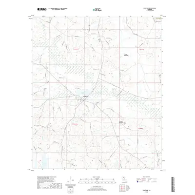
2018 Map of Chatham
USGS Topo · Published 2018About this map
The town of Chatham serves as the focal point of this Jackson Parish landscape, situated at the edge of Chatham Lake and surrounded by a dense network of local routes like Front St and Okaloosa Rd. The area is characterized by a high concentration of small family and community burial grounds, which offer significant value for genealogical research. These sites, including Salem Cem, Old Bethel Cem, Wyatt Cem, and Henson Cem, are scattered across the timberlands and creek bottoms of the region.
Find a feature on this map
91 named features on this map. Tap any name to fly to it.
Don’t see what you’re looking for? This feature index may not catch every label — zoom into the map to look around manually.
Map Details
Editions of this 2018 Chatham Map
This is the sole edition of this map. No revisions or reprints were ever made.
Other maps of this area

1949 · Jonesboro
USGS Topo · 1:62,500

1950 · Jonesboro
USGS Topo · 1:62,500

1953 · Chatham
USGS Topo · 1:62,500

1953 · Hodge
USGS Topo · 1:62,500

1954 · Sikes
USGS Topo · 1:62,500

1955 · Shreveport
USGS Topo · 1:250,000

1956 · Shreveport
USGS Topo · 1:250,000

1982 · Chatham
USGS Topo · 1:24,000

1982 · Chatham SE
USGS Topo · 1:24,000
1982 · Cadeville
USGS Topo · 1:24,000