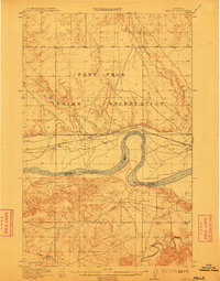
1912 Map of Chelsea
USGS Topo · Published 1912About this map
The Fort Peck Indian Reservation dominates the northern landscape of this region, where the Great Northern railroad tracks parallel the north bank of the Missouri River. Surveyed between 1908 and 1910, the topography illustrates a transition between the wide river valley and the dissected uplands to the south. Small settlements like Chelsea and Nickwall serve as local anchors, while the southern boundary of the reservation follows the river's meandering course. A significant Boundary Line separates Valley County and Dawson County, cutting directly through the Missouri's channel. The map records the early 20th-century hydrology of the area, featuring drainage systems such as Redwater Creek, Boxelder Creek, and Chelsea Creek. The presence of Burch in the southwest corner and various benchmarks throughout the terrain suggests an era of active land measurement and homesteading along the river corridor.
Find a feature on this map
12 named features on this map. Tap any name to fly to it.
Don’t see what you’re looking for? This feature index may not catch every label — zoom into the map to look around manually.
Map Details
Editions of this 1912 Chelsea Map
2 editions found
Other maps of this area

1910 · Cuskers
USGS Topo · 1:62,500

1912 · Chelsea
USGS Topo · 1:62,500

1912 · Hay Creek
USGS Topo · 1:62,500

1912 · Poplar
USGS Topo · 1:62,500

1915 · Tule Valley
USGS Topo · 1:62,500

1915 · Cuskers
USGS Topo · 1:62,500

1916 · Wolf Point
USGS Topo · 1:62,500

1954 · Glendive
USGS Topo · 1:250,000

1954 · Wolf Point
USGS Topo · 1:250,000

1957 · Glendive
USGS Topo · 1:250,000