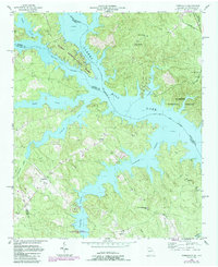
1955 Map of Chennault
USGS Topo · Published 1987About this map
Clarks Hill Lake and the Savannah River dominate this landscape on the border of Georgia and South Carolina, reflecting a mid-century period of significant hydrological change. The inundation of the river valley created an intricate shoreline of fingers and inlets, surrounding high ground where small communities like Chennault and Graball remain. Cultural landmarks like Spring Grove Ch and Mt Pleasant Ch are situated among the ridges, while the Bobby Brown State Park occupies a prominent peninsula where the Broad River meets the Savannah. The map documents late-20th-century developments in purple, including a landing strip and several new structures near New Tabernacle Sch Ch. This convergence of natural forest land, such as the Sumter National Forest, and modern water management reveals a region transitioning from traditional rural settlements to a recreational and conservation-focused landscape.
Find a feature on this map
31 named features on this map. Tap any name to fly to it.
Don’t see what you’re looking for? This feature index may not catch every label — zoom into the map to look around manually.
Map Details
Editions of this 1955 Chennault Map
3 editions found

Other maps of this area

1892 · Mc Cormick
USGS Topo · 1:125,000

1892 · Abbeville
USGS Topo · 1:125,000

1893 · Elberton
USGS Topo · 1:125,000

1906 · Crawfordville
USGS Topo · 1:125,000

1912 · Mc Cormick
USGS Topo · 1:125,000

1949 · Calhoun Creek
USGS Topo · 1:24,000

1953 · Athens
USGS Topo · 1:250,000

1954 · Metasville
USGS Topo · 1:24,000

1954 · Greenville
USGS Topo · 1:250,000

1955 · Tignall
USGS Topo · 1:24,000