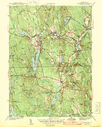
1943 Map of Chepachet
USGS Topo · Published 1943About this map
Durfee Hill, the state's highest elevation, stands prominently in the southwest corner of this Providence County landscape. During the early 1940s, the region was defined by a dense network of reservoirs and manufacturing villages centered on the Clear River and Branch River. Settlements like Pascoag, Harrisville, and Bridgeton are shown in detail, linked by the New York New Haven and Hartford RR. The industrial and social character of the era is evidenced by features ranging from the Iron Mine near Wallum Brook to the Pascoag Race Track and the Burrillville High Sch. In Glocester, the Chepachet Cem and various family-named hills like Tourtellotte Hill reflect the deep genealogical roots of these upland communities before post-war suburbanization altered the traditional village patterns.
Find a feature on this map
64 named features on this map. Tap any name to fly to it.
Don’t see what you’re looking for? This feature index may not catch every label — zoom into the map to look around manually.
Map Details
Editions of this 1943 Chepachet Map
3 editions found
Other maps of this area

1886 · Blackstone
USGS Topo · 1:62,500

1889 · Blackstone
USGS Topo · 1:62,500

1889 · Webster
USGS Topo · 1:62,500

1889 · Putnam
USGS Topo · 1:62,500

1889 · Burrillville
USGS Topo · 1:62,500

1892 · Webster
USGS Topo · 1:62,500

1893 · Putnam
USGS Topo · 1:62,500

1893 · Blackstone
USGS Topo · 1:62,500

1894 · Burrillville
USGS Topo · 1:62,500

1900 · Blackstone
USGS Topo · 1:62,500
Featured Places
- Burrillville, RI
- Glocester, RI
- Mapleville, Burrillville
- Harrisville, Burrillville
- Glendale, Burrillville