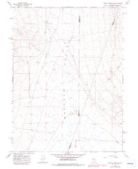
1965 Map of Cherry Creek SE
USGS Topo · Published 1981About this map
Buffalo Valley dominates this High Desert landscape, where the convergence of three Nevada counties — Pershing, Humboldt, and Lander — is meticulously recorded. The terrain is defined by the ephemeral flow of Cherry Creek and Timber Creek, which descend toward the valley floor from the surrounding highlands. A single prospect located in the southeastern quadrant serves as a solitary marker of mineral exploration in this desolate reach, reflecting the transient nature of mining efforts in the region during the mid-20th century. The 1981 revisions, based on 1980 aerial photography, provide updated data on the primitive road network and light-duty tracks that navigate the expansive valley, offering a precise view of the area's geography before later development or environmental shifts.
Find a feature on this map
7 named features on this map. Tap any name to fly to it.
Don’t see what you’re looking for? This feature index may not catch every label — zoom into the map to look around manually.
Map Details
Editions of this 1965 Cherry Creek SE Map
2 editions found
Other maps of this area

1932 · Sonoma Range
USGS Topo · 1:250,000

1939 · Sonoma Range
USGS Topo · 1:250,000

1940 · Antler Peak
USGS Topo · 1:62,500

1943 · Antler Peak
USGS Topo · 1:62,500

1955 · Winnemucca
USGS Topo · 1:250,000

1958 · Winnemucca
USGS Topo · 1:250,000

1961 · McCoy
USGS Topo · 1:62,500

1962 · Winnemucca
USGS Topo · 1:250,000

1962 · Buffalo Springs
USGS Topo · 1:62,500
1965 · Cherry Creek NE
USGS Topo · 1:24,000