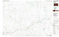
1986 Map of Cherry Creek
USGS Topo · Published 1986About this map
The Cheyenne River Indian Reservation dominates the northern half of this landscape, where the Cheyenne River carves a deep path toward its confluence with Lake Oahe. The settlement of Cherry Creek sits at a strategic bend in the river, serving as a focal point for a region defined by expansive prairie flats and distinctive topographic landmarks. High points like Rattlesnake Butte and Squaw Teat Butte rise above the surrounding terrain, while an Old Railroad Grade in the northeast hints at former transportation corridors. South of the river, small communities such as Milesville and Kirley are connected by a network of roads and drainages like Hermaphrodite Creek and Bull Creek. Numerous small water control structures, including Staple M Dam and Miller Dam, dot the landscape, illustrating the vital role of water management in this high plains environment.
Find a feature on this map
100 named features on this map. Tap any name to fly to it.
Don’t see what you’re looking for? This feature index may not catch every label — zoom into the map to look around manually.
Map Details
Editions of this 1986 Cherry Creek Map
2 editions found
Other maps of this area

1953 · Rapid City
USGS Topo · 1:250,000

1953 · McIntosh
USGS Topo · 1:250,000

1954 · Lemmon
USGS Topo · 1:250,000

1954 · Pierre
USGS Topo · 1:250,000

1955 · Bridger
USGS Topo · 1:24,000

1955 · Rattlesnake Lake SE
USGS Topo · 1:24,000

1955 · Pedro
USGS Topo · 1:24,000

1955 · Rattlesnake Lake SW
USGS Topo · 1:24,000

1955 · Rattlesnake Lake
USGS Topo · 1:24,000

1955 · Rattlesnake Lake NE
USGS Topo · 1:24,000