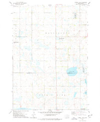
1973 Map of Cherry Lake
USGS Topo · Published 1978About this map
The glacial prairie landscape of the eastern Dakotas is defined here by an intricate network of wetlands and shallow basins straddling the Clark Co Kingsbury Co line. In the early 1970s, this area was heavily managed for conservation and wildlife habitat, as evidenced by large tracts dedicated to the National Waterfowl Production Area and the Staden Slough State Public Shooting Area. The topography is a series of depressions and rises that give way to larger water bodies like Cherry Lake and the northern reaches of Spirit Lake.
Find a feature on this map
13 named features on this map. Tap any name to fly to it.
Don’t see what you’re looking for? This feature index may not catch every label — zoom into the map to look around manually.
Map Details
Editions of this 1973 Cherry Lake Map
This is the sole edition of this map. No revisions or reprints were ever made.
Other maps of this area

1899 · De Smet
USGS Topo · 1:125,000

1953 · Watertown
USGS Topo · 1:250,000

1958 · Watertown
USGS Topo · 1:250,000

1968 · Erwin
USGS Topo · 1:24,000

1971 · Bancroft East
USGS Topo · 1:24,000

1971 · De Smet
USGS Topo · 1:24,000

1973 · Willow Lake
USGS Topo · 1:24,000

1973 · Bryant
USGS Topo · 1:24,000

1973 · Vienna West
USGS Topo · 1:24,000
1973 · Willow Lake SW
USGS Topo · 1:24,000