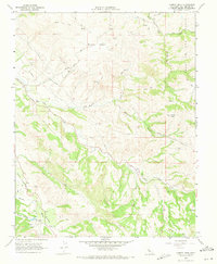
1968 Map of Cherry Peak
USGS Topo · Published 1971About this map
Cherry Peak stands as the central high point of this terrain, overlooking a landscape defined by dramatic geological activity and cattle ranching in San Benito County. The western portion of the map is dominated by the San Andreas Rift Zone, where the San Benito River flows alongside the rift and Stone Canyon. The area’s human history is marked by established outposts like Elkhorn Ranch and the 101 Ranch, connected by a network of jeep trails and a small Landing Strip.
Find a feature on this map
22 named features on this map. Tap any name to fly to it.
Don’t see what you’re looking for? This feature index may not catch every label — zoom into the map to look around manually.
Map Details
Editions of this 1968 Cherry Peak Map
3 editions found
Other maps of this area

1919 · San Benito
USGS Topo · 1:62,500

1919 · Hollister
USGS Topo · 1:48,000

1921 · Gonzales
USGS Topo · 1:62,500

1921 · Hollister
USGS Topo · 1:62,500

1922 · Quien Sabe
USGS Topo · 1:62,500

1923 · Hollister
USGS Topo · 1:62,500

1931 · San Benito
USGS Topo · 1:62,500

1940 · Hollister
USGS Topo · 1:62,500

1940 · Quien Sabe
USGS Topo · 1:62,500

1940 · San Benito
USGS Topo · 1:62,500