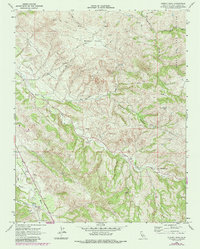
1968 Map of Cherry Peak
USGS Topo · Published 1984About this map
The San Andreas Rift Zone slices through the southwestern portion of this San Benito County survey, defining the alignment of the San Benito River and its surrounding topography. This area is characterized by a network of ranching operations and water management, evidenced by Elkhorn Ranch and 101 Ranch, alongside numerous Water Tanks and a significant Pipeline traversing the hills. A single small Cem is located near a landing strip in the west, while a Mine remains tucked into the slopes near Browns Valley. The drainage patterns are intricate, with Tres Pinos Creek and Los Muertos Creek cutting through the complex terrain toward the high point of Cherry Peak. The 1984 revisions, shown in purple, document updates to the local road and trail systems within these ranchlands.
Find a feature on this map
20 named features on this map. Tap any name to fly to it.
Don’t see what you’re looking for? This feature index may not catch every label — zoom into the map to look around manually.
Map Details
Editions of this 1968 Cherry Peak Map
3 editions found
Other maps of this area

1919 · San Benito
USGS Topo · 1:62,500

1919 · Hollister
USGS Topo · 1:48,000

1921 · Gonzales
USGS Topo · 1:62,500

1921 · Hollister
USGS Topo · 1:62,500

1922 · Quien Sabe
USGS Topo · 1:62,500

1923 · Hollister
USGS Topo · 1:62,500

1931 · San Benito
USGS Topo · 1:62,500

1940 · Hollister
USGS Topo · 1:62,500

1940 · Quien Sabe
USGS Topo · 1:62,500

1940 · San Benito
USGS Topo · 1:62,500