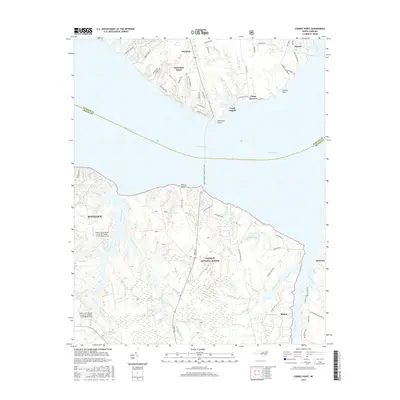
2016 Map of Cherry Point
USGS Topo · Published 2016About this map
The Neuse River dominates this coastal landscape, serving as a broad natural boundary between Pamlico and Craven counties. On the southern shore, the vast Cherry Point Marine Corps Air Station /Cunningham Field and the Croatan National Forest define the land use, where complex drainage systems like Hancock Creek and Cahoogue Creek wind through the timberland. The map documents the vital Cherry Branch - Minnesott Ferry crossing, which remains a primary link for travelers between the northern settlements of Arapahoe and Minnesota Beach and the military hub near Havelock. Along the intricate shoreline, numerous guts and creeks such as Mitchell Creek and Clubfoot Creek offer a detailed view of the tidal environment. This era of the landscape is characterized by the coexistence of established coastal communities like Janeiro and Bachelor alongside large-scale federal installations and youth camps like Camp Seagull.
Find a feature on this map
80 named features on this map. Tap any name to fly to it.
Don’t see what you’re looking for? This feature index may not catch every label — zoom into the map to look around manually.
Map Details
Editions of this 2016 Cherry Point Map
This is the sole edition of this map. No revisions or reprints were ever made.
Other maps of this area

1948 · Oriental
USGS Topo · 1:24,000

1949 · Havelock
USGS Topo · 1:24,000

1949 · Merrimon
USGS Topo · 1:24,000

1949 · Newport
USGS Topo · 1:24,000

1949 · Cherry Point
USGS Topo · 1:24,000

1949 · Core Creek
USGS Topo · 1:24,000

1949 · Masontown
USGS Topo · 1:24,000

1950 · Upper Broad Creek
USGS Topo · 1:24,000

1950 · Arapahoe
USGS Topo · 1:24,000

1951 · Newport
USGS Topo · 1:24,000