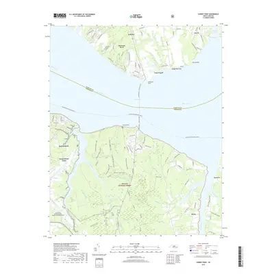
2019 Map of Cherry Point
USGS Topo · Published 2019About this map
MCAS Cherry Point and the sprawling training grounds of the Croatan National Forest dominate this coastal landscape at the confluence of the Neuse River and its many tidal tributaries. The southern bank is defined by military and aviation infrastructure at Cherry Point Marine Corps Air Station/Cunningham Field and the adjacent city of Havelock. North of the river, a different character emerges with small riverfront communities and seasonal escapes such as Minnesota Beach, Arapahoe, and the established youth retreats at Camp Seagull and Camp Don-Lee. The transition from the dense forests of the interior to the marshy points at Wilkinson Point and Pierson Point illustrates the region's historical reliance on both timber resources and the maritime highway. Researchers can trace the winding paths of Clubfoot Creek and Hancock Creek, which have long served as vital drainage and navigation routes for the surrounding lowlands.
Find a feature on this map
96 named features on this map. Tap any name to fly to it.
Don’t see what you’re looking for? This feature index may not catch every label — zoom into the map to look around manually.
Map Details
Editions of this 2019 Cherry Point Map
This is the sole edition of this map. No revisions or reprints were ever made.
Other maps of this area

1948 · Oriental
USGS Topo · 1:24,000

1949 · Havelock
USGS Topo · 1:24,000

1949 · Merrimon
USGS Topo · 1:24,000

1949 · Newport
USGS Topo · 1:24,000

1949 · Cherry Point
USGS Topo · 1:24,000

1949 · Core Creek
USGS Topo · 1:24,000

1949 · Masontown
USGS Topo · 1:24,000

1950 · Upper Broad Creek
USGS Topo · 1:24,000

1950 · Arapahoe
USGS Topo · 1:24,000

1951 · Newport
USGS Topo · 1:24,000