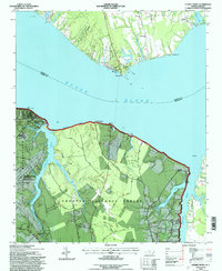
1994 Map of Cherry Point
USGS Topo · Published 1997About this map
The Neuse River divides this coastal landscape, where the northern bank in Pamlico Co meets the expansive military and forest lands of Craven Co to the south. The southern shore is dominated by the US Marine Corps Air Station Cherry Point and the heavily wooded tracts of the Croatan National Forest. Local life is anchored by small coastal settlements like Minnesott Beach and Janeiro, alongside established community centers such as Mt Zion Ch and Weeping Mary Ch.
Find a feature on this map
63 named features on this map. Tap any name to fly to it.
Don’t see what you’re looking for? This feature index may not catch every label — zoom into the map to look around manually.
Map Details
Editions of this 1994 Cherry Point Map
This is the sole edition of this map. No revisions or reprints were ever made.
Other maps of this area

1948 · Oriental
USGS Topo · 1:24,000

1949 · Havelock
USGS Topo · 1:24,000

1949 · Merrimon
USGS Topo · 1:24,000

1949 · Newport
USGS Topo · 1:24,000

1949 · Cherry Point
USGS Topo · 1:24,000

1949 · Core Creek
USGS Topo · 1:24,000

1949 · Masontown
USGS Topo · 1:24,000

1950 · Upper Broad Creek
USGS Topo · 1:24,000

1950 · Arapahoe
USGS Topo · 1:24,000

1951 · Newport
USGS Topo · 1:24,000