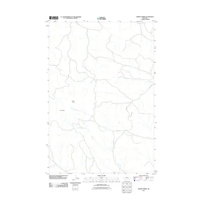
2011 Map of Cherry Spring
USGS Topo · Published 2011About this map
Square Butte and the nearby Three Buttes rise above a landscape defined by an intricate network of drainage channels in this part of Yellowstone County. The area is characterized by the convergence of several ephemeral and seasonal watercourses, including the principal Hawk Creek and its tributary, the Dry Fork Hawk Creek. A specific water source, the 06N28E09ADD_01 Spring, provides a precise point of interest for those studying local hydrology or land use. A sparse road network, including Shepherd Rd and Fishel Creek Rd, navigates the terrain between these prominent landmarks and the deep cuts of Cow Gulch. This 2011 survey captures a quiet, high-plains landscape where topography dictates the path of both the water and the few primitive roads that cross it.
Find a feature on this map
11 named features on this map. Tap any name to fly to it.
Don’t see what you’re looking for? This feature index may not catch every label — zoom into the map to look around manually.
Map Details
Editions of this 2011 Cherry Spring Map
This is the sole edition of this map. No revisions or reprints were ever made.
Other maps of this area

1954 · Roundup
USGS Topo · 1:250,000

1958 · Roundup
USGS Topo · 1:250,000

1979 · Roundup
USGS Topo · 1:100,000

1979 · Corey Flat
USGS Topo · 1:24,000

1979 · Gage NE
USGS Topo · 1:24,000

1979 · Chimney Butte
USGS Topo · 1:24,000
1980 · P K Ranch NE
USGS Topo · 1:24,000
1980 · Steamboat Butte
USGS Topo · 1:24,000

1980 · Cherry Spring
USGS Topo · 1:24,000

1980 · Dunn Mountain South
USGS Topo · 1:24,000