
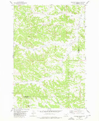
1979 Map of Chimney Butte
USGS Topo · Published 1980About this map
Chimney Butte stands as a prominent landmark in this mid-1970s landscape of rural Musselshell County. The terrain is deeply dissected by numerous watercourses and seasonal drainages, including the prominent Fattig Creek in the west and Fishel Creek to the east. Several named coulees, such as Tepee Coulee, Carters Coulee, and Y Bar Coulee, cut through the hills, illustrating the complex natural drainage patterns of this Montana upland.
Find a feature on this map
13 named features on this map. Tap any name to fly to it.
Don’t see what you’re looking for? This feature index may not catch every label — zoom into the map to look around manually.
Map Details
Editions of this 1979 Chimney Butte Map
This is the sole edition of this map. No revisions or reprints were ever made.
Other maps of this area

1954 · Roundup
USGS Topo · 1:250,000

1958 · Roundup
USGS Topo · 1:250,000

1963 · Musselshell
USGS Topo · 1:24,000

1963 · Delphia
USGS Topo · 1:24,000

1979 · Roundup
USGS Topo · 1:100,000

1979 · Corey Flat
USGS Topo · 1:24,000

1979 · Gage NE
USGS Topo · 1:24,000
1980 · Steamboat Butte
USGS Topo · 1:24,000

1980 · Cherry Spring
USGS Topo · 1:24,000

1980 · Dunn Mountain North
USGS Topo · 1:24,000