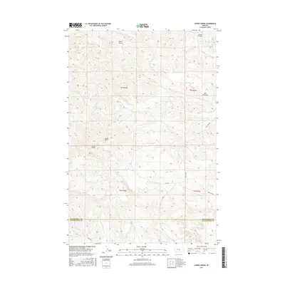
2017 Map of Cherry Spring
USGS Topo · Published 2017About this map
The Bull Mountains dominate the landscape of this southern Montana region, where high desert terrain is defined by dramatic plateaus and deep drainage channels. The map captures a sparsely populated territory along the Musselshell County and Yellowstone County line, characterized by prominent geological landmarks like Square Butte and Three Buttes. Water sources are critical features in this arid environment, evidenced by the named Cherry Spring and the seasonal networks of Hawk Cr and Dry Fork Hawk Cr. The presence of Tepee Coulee and Carters Coulee suggests the complex erosional history of the area. Human activity is primarily represented by a light network of rural routes, such as Fishel Creek Rd and Roen Rd, which serve the remote ranchlands and rangelands of the northern Yellowstone territory.
Find a feature on this map
21 named features on this map. Tap any name to fly to it.
Don’t see what you’re looking for? This feature index may not catch every label — zoom into the map to look around manually.
Map Details
Editions of this 2017 Cherry Spring Map
This is the sole edition of this map. No revisions or reprints were ever made.
Other maps of this area

1954 · Roundup
USGS Topo · 1:250,000

1958 · Roundup
USGS Topo · 1:250,000

1979 · Roundup
USGS Topo · 1:100,000

1979 · Corey Flat
USGS Topo · 1:24,000

1979 · Gage NE
USGS Topo · 1:24,000

1979 · Chimney Butte
USGS Topo · 1:24,000
1980 · P K Ranch NE
USGS Topo · 1:24,000
1980 · Steamboat Butte
USGS Topo · 1:24,000

1980 · Cherry Spring
USGS Topo · 1:24,000

1980 · Dunn Mountain South
USGS Topo · 1:24,000