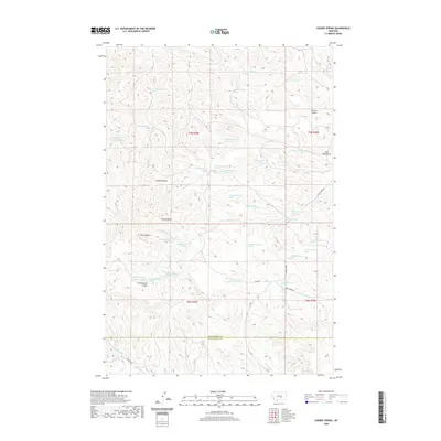
2020 Map of Cherry Spring
USGS Topo · Published 2020About this map
Square Butte and the Bull Mountains dominate this high-plains landscape at the border of Musselshell and Yellowstone Counties. The terrain is defined by a dense network of springs and coulees, reflecting a geography where water access dictated land use. Dozens of mapped water sources, including the namesake Cherry Spring, are scattered across the broken ground of Tepee Coulee and Carters Coulee. Settlement is sparse, represented primarily by a handful of winding local routes such as Fishel Creek Rd and Roen Rd that navigate the drainages of Hawk Cr and Cottonwood Creek. The intricate contouring reveals the complex erosional patterns of the Three Buttes area, providing a clear picture of the Montana backcountry's physical character and the isolated road network serving its remote ranching or grazing lands.
Find a feature on this map
48 named features on this map. Tap any name to fly to it.
Don’t see what you’re looking for? This feature index may not catch every label — zoom into the map to look around manually.
Map Details
Editions of this 2020 Cherry Spring Map
This is the sole edition of this map. No revisions or reprints were ever made.
Other maps of this area

1954 · Roundup
USGS Topo · 1:250,000

1958 · Roundup
USGS Topo · 1:250,000

1979 · Roundup
USGS Topo · 1:100,000

1979 · Corey Flat
USGS Topo · 1:24,000

1979 · Gage NE
USGS Topo · 1:24,000

1979 · Chimney Butte
USGS Topo · 1:24,000
1980 · P K Ranch NE
USGS Topo · 1:24,000
1980 · Steamboat Butte
USGS Topo · 1:24,000

1980 · Cherry Spring
USGS Topo · 1:24,000

1980 · Dunn Mountain South
USGS Topo · 1:24,000