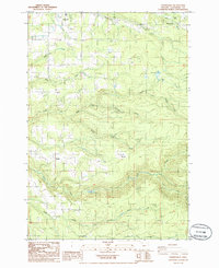
1985 Map of Cherryville
USGS Topo · Published 1986About this map
Eagle Creek and its many tributaries, including North Fork Eagle Creek and South Fork Eagle Creek, define the drainage patterns of this Clackamas County landscape. Small rural communities like Cherryville, Firwood, and George are connected by winding roads through the timbered terrain, reflecting a mid-1980s pattern of residential pockets and light industry. Evidence of resource extraction is found at the Gravel Pits and Quarry, while the presence of a Fish Hatchery and numerous creek labels like Tickle Creek and Delph Creek highlights the area's reliance on its waterway networks. Local history is anchored by sites like the Cem near George and the small settlement at Bissell, while topographic landmarks such as Lenhart Butte provide significant vertical relief for the region.
Find a feature on this map
35 named features on this map. Tap any name to fly to it.
Don’t see what you’re looking for? This feature index may not catch every label — zoom into the map to look around manually.
Map Details
Editions of this 1985 Cherryville Map
This is the sole edition of this map. No revisions or reprints were ever made.
Other maps of this area

1911 · Boring
USGS Topo · 1:48,000

1914 · Boring
USGS Topo · 1:62,500

1916 · Estacada
USGS Topo · 1:125,000

1940 · Boring
USGS Topo · 1:62,500

1948 · Vancouver
USGS Topo · 1:250,000

1950 · Vancouver
USGS Topo · 1:250,000

1950 · Vancouver
USGS Topo · 1:250,000
1954 · Sandy
USGS Topo · 1:24,000
1954 · Estacada
USGS Topo · 1:24,000

1955 · Colton
USGS Topo · 1:62,500