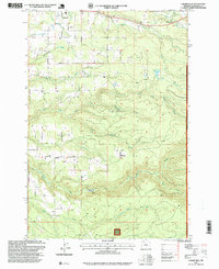
1997 Map of Cherryville
USGS Topo · Published 1999About this map
Cherryville and the surrounding foothill communities of George and Bissell define the landscape of eastern Clackamas County during this late 1990s revision. The area is characterized by a dense network of watercourses, most notably the winding descent of Eagle Creek and its many tributaries, including North Fork Eagle Creek and South Fork Eagle Creek. This map captures a rural environment where small settlements like Firwood and Dover sit adjacent to the expanding boundaries of the Mt Hood National Forest. Local industry and infrastructure are evident through scattered resources such as the Fish Hatchery on the lower reaches of Eagle Creek and various extractive sites like the Quarry and Gravel Pit. Significant local landmarks, including Lenhart Butte and the isolated Hope Lake, provide clear orientation points for researchers tracking the historical transition of these mountain-bordering communities.
Find a feature on this map
32 named features on this map. Tap any name to fly to it.
Don’t see what you’re looking for? This feature index may not catch every label — zoom into the map to look around manually.
Map Details
Editions of this 1997 Cherryville Map
This is the sole edition of this map. No revisions or reprints were ever made.
Other maps of this area

1911 · Boring
USGS Topo · 1:48,000

1914 · Boring
USGS Topo · 1:62,500

1916 · Estacada
USGS Topo · 1:125,000

1940 · Boring
USGS Topo · 1:62,500

1948 · Vancouver
USGS Topo · 1:250,000

1950 · Vancouver
USGS Topo · 1:250,000

1950 · Vancouver
USGS Topo · 1:250,000
1954 · Sandy
USGS Topo · 1:24,000
1954 · Estacada
USGS Topo · 1:24,000

1955 · Colton
USGS Topo · 1:62,500