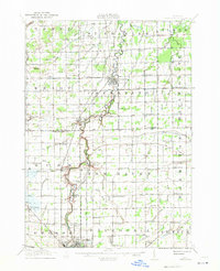
1917 Map of Chesaning
USGS Topo · Published 1941About this map
The Shiawassee River snakes northward through the heart of this Central Michigan landscape, anchoring a network of small agricultural settlements and rural schoolhouses during the early twentieth century. This survey reveals a highly organized drainage system, with numerous named arteries like Wilson School Drain and Blackmer Drain supporting the productive farmlands of St. Charles and Albee. Industrial activity is concentrated at the Six Mile Mine near New Haven, while the Michigan Central Railroad follows the river's course to connect Chesaning with Oakley and Henderson. To the south, the northern limits of Owosso appear, where the Ann Arbor Railroad and Grand Trunk Railroad converge. The map serves as a detailed record of local genealogy, capturing dozens of district schools such as Morleytown School and Dutchtown School, as well as the Griffus Cemetery.
Find a feature on this map
119 named features on this map. Tap any name to fly to it.
Don’t see what you’re looking for? This feature index may not catch every label — zoom into the map to look around manually.
Map Details
Editions of this 1917 Chesaning Map
4 editions found
Other maps of this area

1917 · Chesaning
USGS Topo · 1:62,500

1917 · St. Charles
USGS Topo · 1:62,500

1918 · Elsie
USGS Topo · 1:62,500

1919 · Saginaw
USGS Topo · 1:62,500

1919 · Burt
USGS Topo · 1:62,500

1921 · Burt
USGS Topo · 1:62,500

1922 · Durand
USGS Topo · 1:62,500

1926 · Corunna
USGS Topo · 1:62,500

1928 · Laingsburg
USGS Topo · 1:62,500

1929 · Corunna
USGS Topo · 1:62,500