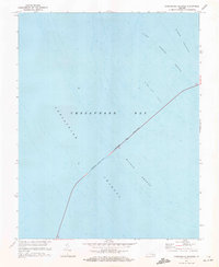
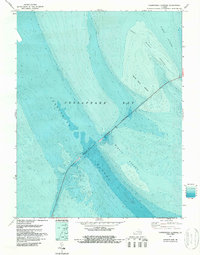
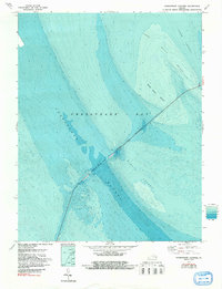
1971 Map of Chesapeake Channel
USGS Topo · Published 1972About this map
Chesapeake Bay Bridge-Tunnel cuts a bold diagonal across the open waters of the Chesapeake Bay in this 1971 study. This map documents a critical infrastructure link, showing the path where the (Toll) road transitions into the Chesapeake Channel tunnel to allow for deep-water shipping. The hydrographic data, compiled from U.S. Coast and Geodetic Survey charts, reveals the complex underwater topography of the lower bay. Maritime researchers can trace the hazardous shallows of Nine Foot Shoal and the shifting sandbars of the Inner Middle Ground and Middle Ground. These features define the natural maritime corridors of the North Channel, illustrating the delicate balance between natural nautical obstacles and the engineering required to bridge them for automotive travel.
Find a feature on this map
7 named features on this map. Tap any name to fly to it.
Don’t see what you’re looking for? This feature index may not catch every label — zoom into the map to look around manually.
Map Details
Editions of this 1971 Chesapeake Channel Map
3 editions found
Other maps of this area

1893 · Virginia Beach
USGS Topo · 1:125,000

1907 · Norfolk
USGS Topo · 1:125,000

1918 · Cape Henry
USGS Topo · 1:62,500

1919 · Cape Henry
USGS Topo · 1:62,500
1943 · Elliots Creek
USGS Topo · 1:25,000

1943 · Townsend
USGS Topo · 1:24,000

1943 · Richmond
USGS Topo · 1:250,000

1946 · Eastville
USGS Topo · 1:250,000

1946 · Currituck Sound
USGS Topo · 1:250,000

1948 · Ocean View
USGS Topo · 1:24,000