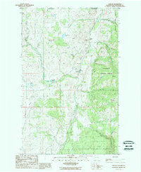
1988 Map of Chesaw
USGS Topo · Published 1988About this map
Chesaw anchors this late 1980s topographical study of northern Okanogan County, just south of the border between the Canada United States and British Columbia Washington boundaries. The landscape is defined by the high elevations of Strawberry Mountain and Buckhorn Mountain, with drainage patterns including Myers Creek and Mary Ann Creek. This region is notable for its legacy of resource extraction, evidenced by numerous mines, a mineshaft, and many prospects scattered across the terrain.
Find a feature on this map
34 named features on this map. Tap any name to fly to it.
Don’t see what you’re looking for? This feature index may not catch every label — zoom into the map to look around manually.
Map Details
Editions of this 1988 Chesaw Map
This is the sole edition of this map. No revisions or reprints were ever made.
Other maps of this area

1902 · Osoyoos
USGS Topo · 1:125,000

1904 · Osoyoos
USGS Topo · 1:125,000

1904 · Republic
USGS Topo · 1:125,000

1951 · Bodie Mountain
USGS Topo · 1:62,500

1954 · Okanogan
USGS Topo · 1:250,000

1957 · Mt. Bonaparte
USGS Topo · 1:62,500

1958 · Okanogan
USGS Topo · 1:250,000

1958 · Bodie Mtn
USGS Topo · 1:62,500

1984 · Oroville
USGS Topo · 1:100,000

1984 · Republic
USGS Topo · 1:100,000