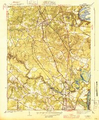
1944 Map of Chester
USGS Topo · Published 1944About this map
Chester serves as a central hub in this mid-century survey, situated at the junction of the Seaboard Air Line and the Atlantic Coast Line railroads. The landscape is defined by the winding course of Swift Creek and its many tributaries, such as Tinsbury Creek and Hanks Branch, which traverse the undulating terrain of Chesterfield County. To the south, the early development of Colonial Heights is visible near the Appomattox River, while the northeastern corner captures a dramatic bend in the James River featuring Farrar Island and the James River (Old Channel). Local social infrastructure is well-documented through scattered rural institutions like Zion Ch, Shiloh Ch, and the Port Walthall Sch. The presence of Lynch Siding and Pickadat Corner highlights small, rail-dependent locales that characterized the area's rural-to-suburban transition before massive post-war expansion.
Find a feature on this map
52 named features on this map. Tap any name to fly to it.
Don’t see what you’re looking for? This feature index may not catch every label — zoom into the map to look around manually.
Map Details
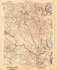
Editions of this 1944 Chester Map
2 editions found
Other maps of this area

1894 · Bermuda Hundred
USGS Topo · 1:62,500

1894 · Petersburg
USGS Topo · 1:62,500

1897 · Amelia
USGS Topo · 1:125,000

1938 · Dutch Gap
USGS Topo · 1:24,000

1938 · Drewrys Bluff
USGS Topo · 1:24,000

1943 · Dutch Gap
USGS Topo · 1:31,680

1943 · Chesterfield
USGS Topo · 1:31,680

1943 · Hopewell
USGS Topo · 1:31,680

1943 · Beach
USGS Topo · 1:24,000

1943 · Sutherland
USGS Topo · 1:24,000