1972 Map of Chester
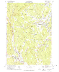
USGS Topo · Published 1975This historical map portrays the area of Chester in 1972, primarily covering Windsor County. Featuring a scale of 1:24000, this map provides a highly detailed snapshot of the terrain, roads, buildings, counties, and historical landmarks in the Chester region at the time. Published in 1975, it is one of 2 known editions of this map due to revisions or reprints.
Find a feature on this map
68 named features on this map. Tap any name to fly to it.
Don’t see what you’re looking for? This feature index may not catch every label — zoom into the map to look around manually.
Map Details
Editions of this 1972 Chester Map
2 editions found
Historical Maps of North Chester Through Time
35 maps found

1906 Hanover
Windsor County, VT

1908 Hanover
Windsor County, VT

1911 Woodstock
Windsor County, VT

1913 Woodstock
Windsor County, VT

1919 Royalton
Windsor County, VT

1924 Randolph
Windsor County, VT

1926 Randolph
Windsor County, VT

1928 Ludlow
Windsor County, VT

1929 Ludlow
Windsor County, VT

1932 Ludlow
Windsor County, VT

1943 Woodstock
Windsor County, VT

1957 Randolph
Windsor County, VT

1959 Hartland
Windsor County, VT

1966 Delectable Mountain
Windsor County, VT

1966 Plymouth
Windsor County, VT

1966 Woodstock North
Windsor County, VT

1966 Woodstock South
Windsor County, VT

1970 Rochester
Windsor County, VT

1971 Andover
Windsor County, VT

1971 Ludlow
Windsor County, VT

1972 Cavendish
Windsor County, VT

1972 Chester
Windsor County, VT

1976 Woodstock North
Windsor County, VT

1980 Bethel
Windsor County, VT

1981 Sharon
Windsor County, VT

1984 Mt. Ascutney
Windsor County, VT

1984 Springfield
Windsor County, VT

1996 Delectable Mountain
Windsor County, VT

1997 Ludlow
Windsor County, VT

1997 Rochester
Windsor County, VT

1997 Woodstock North
Windsor County, VT

1998 Hartland
Windsor County, VT

1998 Springfield
Windsor County, VT

1998 Windsor
Windsor County, VT

1998 Woodstock South
Windsor County, VT