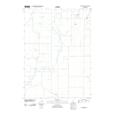
2010 Map of Chesterfield
USGS Topo · Published 2010About this map
The settlement of Chesterfield and the neighboring agricultural valley are defined by a complex network of water management features in this 2010 survey. Irrigation is central to the landscape, evidenced by the Toponce and Chesterfield Land Co Ditch, Kelly Toponce Ditch, and the Downey Canal, which channel water from the Portneuf River and Toponce Creek to sustain local farms. The map documents the grid of rural roads such as Kelly Toponce Rd and Hansen Rd that connect outlying properties and the Chesterfield Cemetery to the historic townsite. Further south, the map tracks the path of Old Hwy 30 near the community of Kinport. This modern USGS study provides a detailed record of land use and water rights in Caribou County, showing how the landscape transition between the valley floor and more rugged terrain like Higginson Canyon has been adapted for ranching and settlement.
Find a feature on this map
32 named features on this map. Tap any name to fly to it.
Don’t see what you’re looking for? This feature index may not catch every label — zoom into the map to look around manually.
Map Details
Editions of this 2010 Chesterfield Map
This is the sole edition of this map. No revisions or reprints were ever made.
Other maps of this area

1917 · Portneuf
USGS Topo · 1:62,500

1948 · Bancroft
USGS Topo · 1:62,500

1949 · Bancroft
USGS Topo · 1:62,500

1954 · Pocatello
USGS Topo · 1:250,000

1955 · Preston
USGS Topo · 1:250,000

1958 · Pocatello
USGS Topo · 1:250,000

1958 · Preston
USGS Topo · 1:250,000

1962 · Preston
USGS Topo · 1:250,000

1968 · Bear Camp Gulch
USGS Topo · 1:24,000
1968 · Haystack Mtn
USGS Topo · 1:24,000