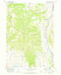
1968 Map of Haystack Mtn
USGS Topo · Published 1973About this map
Caribou National Forest covers much of this high-elevation landscape, where the Portneuf Range divides the drainages of the Portneuf River. The map captures a moment in the late 1960s when the Union Pacific rail line provided the primary industrial corridor along the river valley, passing the small settlement of Pebble. Notable for its historical boundaries, the sheet clearly delineates the Old Indian Treaty Bdy cutting across the southern terrain.
Find a feature on this map
36 named features on this map. Tap any name to fly to it.
Don’t see what you’re looking for? This feature index may not catch every label — zoom into the map to look around manually.
Map Details
Editions of this 1968 Haystack Mtn Map
This is the sole edition of this map. No revisions or reprints were ever made.
Other maps of this area

1917 · Portneuf
USGS Topo · 1:62,500

1948 · Bancroft
USGS Topo · 1:62,500

1949 · Bancroft
USGS Topo · 1:62,500

1954 · Pocatello
USGS Topo · 1:250,000

1955 · Preston
USGS Topo · 1:250,000

1958 · Pocatello
USGS Topo · 1:250,000

1958 · Preston
USGS Topo · 1:250,000

1962 · Preston
USGS Topo · 1:250,000

1968 · Bear Camp Gulch
USGS Topo · 1:24,000

1968 · Lava Hot Springs
USGS Topo · 1:24,000