
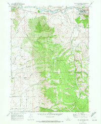
1968 Map of Lava Hot Springs
USGS Topo · Published 1972About this map
Lava Hot Springs occupies a strategic bend of the Portneuf River in this late-1960s survey, where the valley floor meets the rising peaks of the Portneuf Range. The town's layout reflects its dual identity as a railroad stop on the Union Pacific and a developing recreational hub, featuring a Golf Course and numerous hot springs facilities. Outside the town center, the map reveals a rugged landscape defined by water and transit, from the Lava Hot Springs Cem overlooking the valley to the complex network of mountain drainages like Dempsey Creek and Beaverdam Creek. The inclusion of the Treaty Boundary Road and various family-named features such as Christenson Spring and Chatterton Spring provides essential details for those tracing local homesteads or the shifting historical boundaries of southeastern Idaho.
Find a feature on this map
41 named features on this map. Tap any name to fly to it.
Don’t see what you’re looking for? This feature index may not catch every label — zoom into the map to look around manually.
Map Details
Editions of this 1968 Lava Hot Springs Map
2 editions found
Other maps of this area

1915 · Preston
USGS Topo · 1:96,000

1918 · Preston
USGS Topo · 1:125,000

1948 · Bancroft
USGS Topo · 1:62,500

1949 · Bancroft
USGS Topo · 1:62,500

1954 · Pocatello
USGS Topo · 1:250,000

1955 · Preston
USGS Topo · 1:250,000

1958 · Pocatello
USGS Topo · 1:250,000

1958 · Preston
USGS Topo · 1:250,000

1962 · Preston
USGS Topo · 1:250,000

1968 · Downey West
USGS Topo · 1:24,000