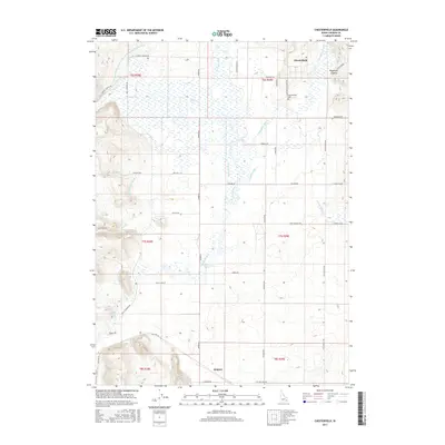
2017 Map of Chesterfield
USGS Topo · Published 2017About this map
Chesterfield sits at the northern edge of this high-elevation agricultural landscape, where the Portneuf River and several of its tributaries wind through a valley defined by irrigation and early transport routes. The presence of the Portneuf Marsh Valley Irrigation Company Feeder Canal and smaller systems like the Downey Canal and Kelly-Toponce Ditch illustrates the vital role of water management in sustaining these Idaho ranching lands. Settlement patterns are sparse, anchored by the town of Kinport in the south and the notable Chesterfield Cemetery near the northern border. Family and place names are preserved in the road network, which includes Kelly Toponce Rd, Shipley Rd, and Miles Rd, tracing historical property boundaries and connection points between the canyons and the open valley floor. Natural features like Higginson Canyon and Orman Spring mark the edges of this managed water landscape.
Find a feature on this map
47 named features on this map. Tap any name to fly to it.
Don’t see what you’re looking for? This feature index may not catch every label — zoom into the map to look around manually.
Map Details
Editions of this 2017 Chesterfield Map
This is the sole edition of this map. No revisions or reprints were ever made.
Other maps of this area

1917 · Portneuf
USGS Topo · 1:62,500

1948 · Bancroft
USGS Topo · 1:62,500

1949 · Bancroft
USGS Topo · 1:62,500

1954 · Pocatello
USGS Topo · 1:250,000

1955 · Preston
USGS Topo · 1:250,000

1958 · Pocatello
USGS Topo · 1:250,000

1958 · Preston
USGS Topo · 1:250,000

1962 · Preston
USGS Topo · 1:250,000

1968 · Bear Camp Gulch
USGS Topo · 1:24,000
1968 · Haystack Mtn
USGS Topo · 1:24,000