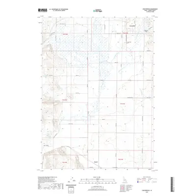
2020 Map of Chesterfield
USGS Topo · Published 2020About this map
Chesterfield sits at the northern edge of this high-plateau landscape, where the early Mormon settlement's grid is preserved amidst a complex network of water management features. The irrigation history of Caribou County is clearly visible through the winding Portneuf Marsh Valley Irrigation Company Feeder Canal and the Downey Canal, which divert water to support agriculture in this arid region. The Portneuf River meanders through the central valley, flanked by numerous natural springs like Grim Springs and Orman Spring. To the south, the settlement of Kinport borders a region defined by sharp terrain shifts, including the entrance to Deer Canyon and the rocky outcrops near Ten Mile Pass Rd. Genealogists will find the Chesterfield Cem and various family-named roads, such as Kelly Toponce Rd and Hansen Rd, helpful for tracing local land use and residency patterns.
Find a feature on this map
46 named features on this map. Tap any name to fly to it.
Don’t see what you’re looking for? This feature index may not catch every label — zoom into the map to look around manually.
Map Details
Editions of this 2020 Chesterfield Map
This is the sole edition of this map. No revisions or reprints were ever made.
Other maps of this area

1917 · Portneuf
USGS Topo · 1:62,500

1948 · Bancroft
USGS Topo · 1:62,500

1949 · Bancroft
USGS Topo · 1:62,500

1954 · Pocatello
USGS Topo · 1:250,000

1955 · Preston
USGS Topo · 1:250,000

1958 · Pocatello
USGS Topo · 1:250,000

1958 · Preston
USGS Topo · 1:250,000

1962 · Preston
USGS Topo · 1:250,000

1968 · Bear Camp Gulch
USGS Topo · 1:24,000
1968 · Haystack Mtn
USGS Topo · 1:24,000