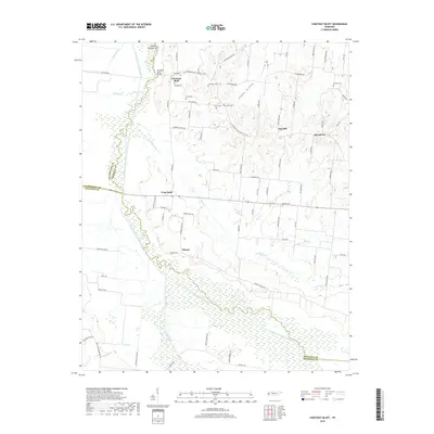
2019 Map of Chestnut Bluff
USGS Topo · Published 2019About this map
Chestnut Bluff sits prominently near the South Fork Forked Deer River, a focal point in a landscape defined by the winding hydrology of West Tennessee. The river corridor, punctuated by features like Island Number Six and the Chestnut Bluff Bridge, serves as a natural boundary between Lauderdale, Crockett, and Haywood counties. Small agricultural communities like Frog Jump, Elmore, and Broadview are linked by a network of rural roads such as the Chestnut Bluff Maury City Rd, reflecting a long-standing settlement pattern centered on the fertile land between the river and its many tributaries, including Black Creek and Bear Creek.
Find a feature on this map
83 named features on this map. Tap any name to fly to it.
Don’t see what you’re looking for? This feature index may not catch every label — zoom into the map to look around manually.
Map Details
Editions of this 2019 Chestnut Bluff Map
This is the sole edition of this map. No revisions or reprints were ever made.
Other maps of this area

1939 · Halls
USGS Topo · 1:62,500

1952 · Gates
USGS Topo · 1:24,000

1952 · Bonicord
USGS Topo · 1:24,000

1952 · Chestnut Bluff
USGS Topo · 1:24,000

1952 · Fowlkes
USGS Topo · 1:24,000

1956 · Blytheville
USGS Topo · 1:250,000

1959 · Blytheville
USGS Topo · 1:250,000

1961 · Jones
USGS Topo · 1:24,000

1961 · Halls
USGS Topo · 1:62,500
1964 · Tibbs
USGS Topo · 1:24,000