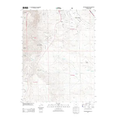
2013 Map of Cheyenne Mountain
USGS Topo · Published 2013About this map
Fort Carson dominates the eastern landscape of this El Paso County survey, showing the complex road network and infrastructure of the military installation including Butts Army Airfield and numerous street names like Titus Blvd and Prussman Blvd. To the west, the terrain rises sharply toward the iconic summit of Cheyenne Mountain and the eastern edge of the Pike National Forest. This transition from the urban-military grid to the steep Front Range topography is marked by several traditional land holdings and unique sites, such as the J L Ranch, Hitch Rack Ranch, and the Louisiana State University Camp. Water management is prominent throughout the foothills, with the Keeton Reservoir, John Townsend Reservoir, and Haymes Reservoir catching runoff from canyons like Deadman Canyon and Sand Canyon. Notable local history markers include the Paupers Cem and the recreational grounds of Rock Creek Park.
Find a feature on this map
72 named features on this map. Tap any name to fly to it.
Don’t see what you’re looking for? This feature index may not catch every label — zoom into the map to look around manually.
Map Details
Editions of this 2013 Cheyenne Mountain Map
This is the sole edition of this map. No revisions or reprints were ever made.
Other maps of this area

1893 · Colorado Springs
USGS Topo · 1:125,000

1909 · Colorado Springs
USGS Topo · 1:125,000

1942 · Colorado Springs
USGS Topo · 1:125,000

1948 · Mount Big Chief
USGS Topo · 1:24,000

1948 · Mount Pittsburg
USGS Topo · 1:24,000

1948 · Timber Mountain
USGS Topo · 1:24,000

1948 · Manitou Springs
USGS Topo · 1:24,000

1948 · Colorado Springs
USGS Topo · 1:62,500

1948 · Fountain
USGS Topo · 1:24,000

1948 · Colorado Springs
USGS Topo · 1:24,000