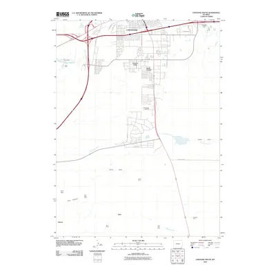
2010 Map of Cheyenne South
USGS Topo · Published 2010About this map
Cheyenne expansion southward defines this 2010 topographic record, showing the residential and commercial developments of Orchard Valley and South Greeley as they branch out from the urban core. The landscape transitions from the dense grid of the city into a series of rural camps and specialized agricultural or industrial sites including Prosser Corral and the Intermountain Speedway. Significant drainage systems like Little Crow Creek and Clear Creek weave through the terrain, punctuated by the Swan Reservoir and the Swan Dam near Swan Camp. Further south, the map reveals a more sparsely populated landscape characterized by topographical features such as the Terry Anticline and the Terry Peak, alongside working sites like the McCard Pit Number One. Historical encampments including Athol Camp, State Line Camp, and Chambers Camp appear near the southern boundary, offering a detailed view of the area's rural infrastructure and land use patterns.
Find a feature on this map
31 named features on this map. Tap any name to fly to it.
Don’t see what you’re looking for? This feature index may not catch every label — zoom into the map to look around manually.
Map Details
Editions of this 2010 Cheyenne South Map
This is the sole edition of this map. No revisions or reprints were ever made.
Other maps of this area

1908 · Eaton
USGS Topo · 1:125,000

1910 · Eaton
USGS Topo · 1:125,000

1911 · Cheyenne
USGS Topo · 1:125,000

1914 · Cheyenne
USGS Topo · 1:125,000

1950 · Cheyenne
USGS Topo · 1:62,500

1954 · Cheyenne
USGS Topo · 1:250,000

1954 · Greeley
USGS Topo · 1:250,000

1957 · Greeley
USGS Topo · 1:250,000

1958 · Cheyenne
USGS Topo · 1:250,000

1958 · Greeley
USGS Topo · 1:250,000