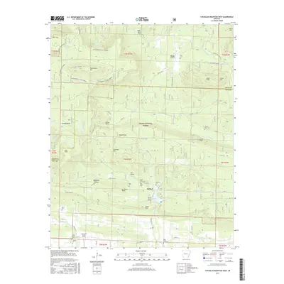
2017 Map of Chickalah Mountain West
USGS Topo · Published 2017About this map
Harkey Valley and Gum Tree sit at the center of this rural landscape, which is defined by the high elevations of Huckleberry Mtn and Chickalah Mtn. The terrain is characterized by deep hollows like Egypt Hollow and Titus Hollow, while numerous watercourses including Chickalah Cr and White Cr drain the valleys. This area within the Ozark National Forest shows a scattered pattern of family heritage and early settlement, evidenced by the high density of small burial sites such as the Sides Family Cem, Smith Family Cem, and the solitary Abbott Grave. In the southern portion of the map, modern utility is represented by the Cedar Creek Ranch Airport and the village of Stafford near the Spring Lake Bridge.
Find a feature on this map
79 named features on this map. Tap any name to fly to it.
Don’t see what you’re looking for? This feature index may not catch every label — zoom into the map to look around manually.
Map Details
Editions of this 2017 Chickalah Mountain West Map
This is the sole edition of this map. No revisions or reprints were ever made.
Other maps of this area

1879 · Mountain Home
USGS Topo · 1:62,500

1887 · Magazine Mountain #1
USGS Topo · 1:62,500

1887 · Magazine Mountain #4
USGS Topo · 1:62,500

1887 · Magazine Mountain
USGS Topo · 1:62,500

1888 · Dardanelle #2
USGS Topo · 1:62,500

1888 · Dardanelle #3
USGS Topo · 1:62,500

1890 · Magazine Mountain
USGS Topo · 1:125,000

1890 · Dardanelle
USGS Topo · 1:125,000

1956 · Russellville
USGS Topo · 1:250,000
1961 · Scranton
USGS Topo · 1:24,000