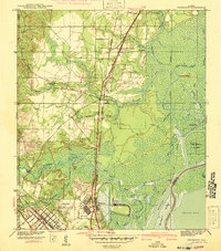
1941 Map of Chickasaw
USGS Topo · Published 1941About this map
Industrial activity and rail expansion dominate this 1941 survey of the Mobile River delta. The Ship Yard at Chickasaw stands as a focal point of maritime production, flanked by the sprawling wetlands of Mobile Island and Twelvemile Island. The landscape is defined by its complex waterway network, where the Mobile River meets a labyrinth of tributaries like Chickasaw Creek, Gunnison Creek, and Black Bayou.
Find a feature on this map
47 named features on this map. Tap any name to fly to it.
Don’t see what you’re looking for? This feature index may not catch every label — zoom into the map to look around manually.
Map Details
Editions of this 1941 Chickasaw Map
2 editions found
Other maps of this area

1921 · Fairhope
USGS Topo · 1:62,500

1922 · Mobile
USGS Topo · 1:62,500

1940 · Mobile
USGS Topo · 1:31,680

1940 · Mobile
USGS Topo · 1:62,500

1941 · Chickasaw
USGS Topo · 1:31,680

1941 · Blakeley
USGS Topo · 1:31,680

1941 · Bay Minette
USGS Topo · 1:62,500

1941 · Creola
USGS Topo · 1:62,500

1941 · Fairhope
USGS Topo · 1:62,500

1942 · Hurricane
USGS Topo · 1:31,680