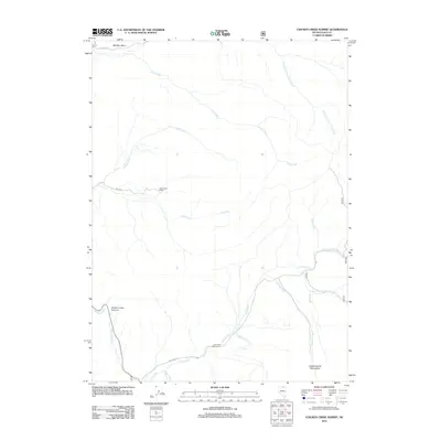
2012 Map of Chicken Creek Summit
USGS Topo · Published 2012About this map
The Independence Mountains dominate the southeastern landscape of this Elko County region, where high-altitude drainages define the remote terrain. This 2012 survey illustrates a network of mountain waterways, including the convergence of Frost Creek, Sheep Creek, and the long reach of Jack Creek as they descend from the summits. Human presence in this high-country environment is concentrated around the Deep Creek Ranch and the Jack Creek Campground, located near the southern margin. The map provides clear detail of the passage through Chicken Creek Summit, a critical geographical point in the western portion of the quadrangle. Significant forest access routes, such as NFD 165 Rd and NFD Road 473, provide the primary infrastructure for navigating the basin. From the expanse of Bull Run Basin in the north to the complex creek systems like Ott Creek and Mill Creek in the south, the map documents a landscape defined by its rugged hydrology and mountain passes.
Find a feature on this map
21 named features on this map. Tap any name to fly to it.
Don’t see what you’re looking for? This feature index may not catch every label — zoom into the map to look around manually.
Map Details
Editions of this 2012 Chicken Creek Summit Map
This is the sole edition of this map. No revisions or reprints were ever made.
Other maps of this area

1955 · McDermitt
USGS Topo · 1:250,000

1955 · Wells
USGS Topo · 1:250,000

1956 · Tuscarora
USGS Topo · 1:62,500

1956 · Bull Run
USGS Topo · 1:62,500

1956 · Wild Horse
USGS Topo · 1:62,500

1958 · Wells
USGS Topo · 1:250,000

1959 · McDermitt
USGS Topo · 1:250,000

1961 · Wells
USGS Topo · 1:250,000

1971 · California Mtn.
USGS Topo · 1:24,000
1981 · Jarbidge Mts
USGS Topo · 1:100,000