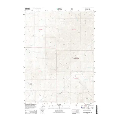
2014 Map of Chicken Creek Summit
USGS Topo · Published 2014About this map
Chicken Creek Summit sits at the heart of this high-elevation landscape within the northern Independence Mountains. This 2014 survey details the complex drainage patterns of the Humboldt National Forest, where numerous seasonal and perennial streams like Sheep Cr, Frost Cr, and Jack Cr radiate from the central ridgelines. The absence of permanent settlements emphasizes the region's character as a resource-focused backcountry area, managed through a network of forest service routes. Navigation and land use are dictated by the Natl Forest Develop Road 473 Rd and the Bullrun route, which provide access through the steep terrain. For those studying the hydrography of Elko County, the map clearly delineates the headwaters of Mill Cr and its tributaries, including E Fork Mill Cr and S Fork E Fork Mill Cr, alongside the drainages of Dorsey Cr and Ott Cr.
Find a feature on this map
23 named features on this map. Tap any name to fly to it.
Don’t see what you’re looking for? This feature index may not catch every label — zoom into the map to look around manually.
Map Details
Editions of this 2014 Chicken Creek Summit Map
This is the sole edition of this map. No revisions or reprints were ever made.
Other maps of this area

1955 · McDermitt
USGS Topo · 1:250,000

1955 · Wells
USGS Topo · 1:250,000

1956 · Tuscarora
USGS Topo · 1:62,500

1956 · Bull Run
USGS Topo · 1:62,500

1956 · Wild Horse
USGS Topo · 1:62,500

1958 · Wells
USGS Topo · 1:250,000

1959 · McDermitt
USGS Topo · 1:250,000

1961 · Wells
USGS Topo · 1:250,000

1971 · California Mtn.
USGS Topo · 1:24,000
1981 · Jarbidge Mts
USGS Topo · 1:100,000