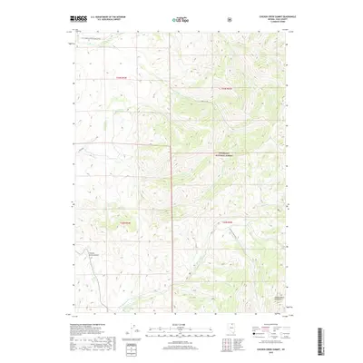
2018 Map of Chicken Creek Summit
USGS Topo · Published 2018About this map
Chicken Creek Summit sits at the heart of this high-elevation landscape within the Humboldt National Forest, where the high peaks of the Independence Mountains dictate the drainage patterns of the Great Basin. Numerous seasonal and perennial streams, including Frost Cr, Sheep Cr, and Deep Cr, carve deep paths through the township boundaries of T43N and T42N. The map illustrates a network of primitive and forest service access points, such as the Chicken Creek Route and Bullrun, which follow the natural contours of the land. These corridors represent the essential infrastructure for ranching and forest management in this part of Elko County, providing passage between the high ridges and the creek beds like Coffin Cr and Ott Cr.
Find a feature on this map
20 named features on this map. Tap any name to fly to it.
Don’t see what you’re looking for? This feature index may not catch every label — zoom into the map to look around manually.
Map Details
Editions of this 2018 Chicken Creek Summit Map
This is the sole edition of this map. No revisions or reprints were ever made.
Other maps of this area

1955 · McDermitt
USGS Topo · 1:250,000

1955 · Wells
USGS Topo · 1:250,000

1956 · Tuscarora
USGS Topo · 1:62,500

1956 · Bull Run
USGS Topo · 1:62,500

1956 · Wild Horse
USGS Topo · 1:62,500

1958 · Wells
USGS Topo · 1:250,000

1959 · McDermitt
USGS Topo · 1:250,000

1961 · Wells
USGS Topo · 1:250,000

1971 · California Mtn.
USGS Topo · 1:24,000
1981 · Jarbidge Mts
USGS Topo · 1:100,000