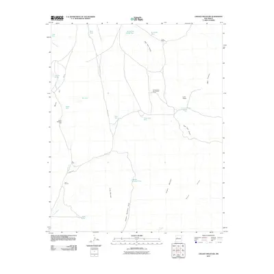
2010 Map of Chicken Mountain
USGS Topo · Published 2010About this map
Sierra Lucero and Chicken Mountain anchor this arid New Mexico landscape, which centers on water management and ranching infrastructure. The network of human activity is primarily defined by numerous watering features like Rough and Muddy Tank, Three Way Tank, and the T X Diversion Dam Number Three. These catchments, along with named sites like Virgils Windmill and Davy Windmill, illustrate the vital efforts to sustain livestock and life in this dry environment. The isolated Pie Ranch serves as a lone settlement hub connected by Indian Rte 55, which traverses the terrain alongside the prominent Mesa del Oro and Mesa Cimarron. This 2010 survey provides a clear view of the topographic contours and drainage systems, such as Rock Tank Canyon and Chicken Mountain Draw, that dictate the movement of both water and travel through the high desert.
Find a feature on this map
28 named features on this map. Tap any name to fly to it.
Don’t see what you’re looking for? This feature index may not catch every label — zoom into the map to look around manually.
Map Details
Editions of this 2010 Chicken Mountain Map
This is the sole edition of this map. No revisions or reprints were ever made.
Other maps of this area

1917 · Cerro Verde
USGS Topo · 1:125,000

1954 · Socorro
USGS Topo · 1:250,000

1956 · South Garcia
USGS Topo · 1:62,500

1956 · Mesa Aparejo
USGS Topo · 1:62,500

1958 · Socorro
USGS Topo · 1:250,000

1960 · Cerro Verde
USGS Topo · 1:24,000

1961 · Marmon Ranch
USGS Topo · 1:24,000

1962 · Socorro
USGS Topo · 1:250,000

1964 · Field Ranch
USGS Topo · 1:24,000
1964 · Cerro Del Oro
USGS Topo · 1:24,000