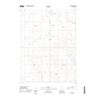
2018 Map of Chicken Springs
USGS Topo · Published 2018About this map
Thousand Springs Valley and the surrounding high-desert basins of northeast Elko County define this landscape of seasonal drainages and remote cattle range. The map captures the hydrological network of the Great Basin, where Thousand Springs Cr is fed by various tributaries like Rock Spring Cr and Sulphur Cr. Notable landmarks for navigation in this territory include Tony Mtn and the prominent Ninemile Ridge, which rise above the sagebrush flats. Human activity is centered on scattered water sources like Chicken Springs and Mud Springs, which have long been vital in this arid environment. The road network is dominated by the Wilkins-Montello Rd and the California Back Country By-Way, tracing routes through Well Spring Valley toward the eastern Delano Mountains. The artificial 23 Mile Reservoir stands as a significant hydrological feature in the southeastern corner of the quadrangle.
Find a feature on this map
22 named features on this map. Tap any name to fly to it.
Don’t see what you’re looking for? This feature index may not catch every label — zoom into the map to look around manually.
Map Details
Editions of this 2018 Chicken Springs Map
This is the sole edition of this map. No revisions or reprints were ever made.
Other maps of this area

1955 · Wells
USGS Topo · 1:250,000

1958 · Wells
USGS Topo · 1:250,000

1961 · Wells
USGS Topo · 1:250,000

1961 · Delano Mountains
USGS Topo · 1:62,500

1967 · Ninemile Mtn NE
USGS Topo · 1:24,000

1967 · Ninemile Mtn
USGS Topo · 1:24,000

1968 · Knoll Mountain SE
USGS Topo · 1:24,000

1968 · Texas Spring
USGS Topo · 1:24,000
1968 · Wine Cup Ranch NE
USGS Topo · 1:24,000
1980 · Dry Canyon
USGS Topo · 1:24,000