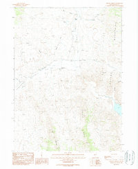
1989 Map of Chicken Springs
USGS Topo · Published 1989About this map
The Emigrant Trail cuts through this high desert terrain in northeastern Nevada, marking a path of westward expansion that aligns with the natural geography of Thousand Valley. Water sources were critical in this arid landscape, evidenced by the clustered locations of Chicken Springs, Mud Springs, and the flow of Rock Spring Creek. The map provides a detailed view of the surrounding mountain architecture, dominated by the Delano Mountains to the east and the prominent peak of Tony Mountain in the south. Between these heights, the Ninemile Ridge and Thousand Springs area define a complex network of drainages and canyons, including Bell Canyon and Burnt Creek Canyon, which have historically dictated travel and land use in this corner of Elko County.
Find a feature on this map
12 named features on this map. Tap any name to fly to it.
Don’t see what you’re looking for? This feature index may not catch every label — zoom into the map to look around manually.
Map Details
Editions of this 1989 Chicken Springs Map
This is the sole edition of this map. No revisions or reprints were ever made.
Other maps of this area

1955 · Wells
USGS Topo · 1:250,000

1958 · Wells
USGS Topo · 1:250,000

1961 · Wells
USGS Topo · 1:250,000

1961 · Delano Mountains
USGS Topo · 1:62,500

1967 · Ninemile Mtn NE
USGS Topo · 1:24,000

1967 · Ninemile Mtn
USGS Topo · 1:24,000

1968 · Knoll Mountain SE
USGS Topo · 1:24,000

1968 · Texas Spring
USGS Topo · 1:24,000
1968 · Wine Cup Ranch NE
USGS Topo · 1:24,000
1980 · Dry Canyon
USGS Topo · 1:24,000