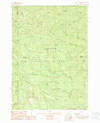
1989 Map of Chilcoot Mountain
USGS Topo · Published 1990About this map
Chilcoot Ridge and the high peaks of the Umpqua National Forest define this landscape along the border of Lane and Douglas counties. Recorded in the late 1980s, the terrain is shaped by a dense network of drainages including Canton Creek, McKinley Creek, and Steamboat Creek. Significant elevations are marked by McKinley Rock, Lemon Butte, and the summit of Chilcoot Mountain, which is notable for its Radio Tower.
Find a feature on this map
32 named features on this map. Tap any name to fly to it.
Don’t see what you’re looking for? This feature index may not catch every label — zoom into the map to look around manually.
Map Details
Editions of this 1989 Chilcoot Mountain Map
This is the sole edition of this map. No revisions or reprints were ever made.
Other maps of this area

1935 · Lowell
USGS Topo · 1:96,000

1942 · Lowell
USGS Topo · 1:125,000

1955 · Mace Mtn
USGS Topo · 1:62,500

1955 · Illahee Rock
USGS Topo · 1:62,500

1955 · Fairview Peak
USGS Topo · 1:62,500

1955 · Culp Creek
USGS Topo · 1:62,500

1958 · Roseburg
USGS Topo · 1:250,000

1959 · Roseburg
USGS Topo · 1:250,000

1978 · Diamond Lake
USGS Topo · 1:100,000

1983 · Oakridge
USGS Topo · 1:100,000