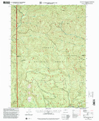
1998 Map of Chilcoot Mountain
USGS Topo · Published 2000About this map
Umpqua National Forest land dominates this 1998 survey, showcasing a landscape defined by high timber ridges and the complex drainage systems of the Oregon Cascades. The terrain is anchored by Chilcoot Ridge and the prominent Chilcoot Mountain, which serves as a literal high point and a site for the Chilcoot Mountain Comm Tower. The map details the divide between Lane Co and Douglas Co, tracing a remote boundary through dense topography where several named peaks like McKinley Rock and Johnson Butte rise above the watershed.
Find a feature on this map
29 named features on this map. Tap any name to fly to it.
Don’t see what you’re looking for? This feature index may not catch every label — zoom into the map to look around manually.
Map Details
Editions of this 1998 Chilcoot Mountain Map
This is the sole edition of this map. No revisions or reprints were ever made.
Other maps of this area

1935 · Lowell
USGS Topo · 1:96,000

1942 · Lowell
USGS Topo · 1:125,000

1955 · Mace Mtn
USGS Topo · 1:62,500

1955 · Illahee Rock
USGS Topo · 1:62,500

1955 · Fairview Peak
USGS Topo · 1:62,500

1955 · Culp Creek
USGS Topo · 1:62,500

1958 · Roseburg
USGS Topo · 1:250,000

1959 · Roseburg
USGS Topo · 1:250,000

1978 · Diamond Lake
USGS Topo · 1:100,000

1983 · Oakridge
USGS Topo · 1:100,000