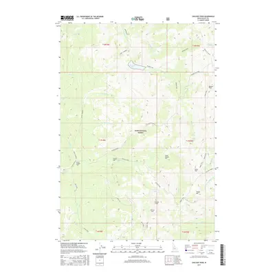
2017 Map of Chilcoot Peak
USGS Topo · Published 2017About this map
The Boise National Forest encompasses this high-elevation terrain in Valley County, where the hydrological divide between the N Fork Riordan Cr and the numerous forks of Bear Cr shapes the landscape. Evidence of high-country resource extraction is marked by the Springfield Mine, located near the southern reaches of Trapper Flat. The mapping reveals a network of high-altitude trails and vantage points, including the Summit Trail which traverses the eastern ridges and the Meadow Cr Lookout in the northeast corner.
Find a feature on this map
41 named features on this map. Tap any name to fly to it.
Don’t see what you’re looking for? This feature index may not catch every label — zoom into the map to look around manually.
Map Details
Editions of this 2017 Chilcoot Peak Map
This is the sole edition of this map. No revisions or reprints were ever made.
Other maps of this area

1937 · Yellow Pine
USGS Topo · 1:48,000

1943 · Yellow Pine
USGS Topo · 1:62,500

1954 · Warm Lake
USGS Topo · 1:62,500

1957 · Challis
USGS Topo · 1:250,000

1960 · Challis
USGS Topo · 1:250,000

1961 · Chinook Mtn
USGS Topo · 1:62,500

1963 · Challis
USGS Topo · 1:250,000
1973 · Big Chief Creek
USGS Topo · 1:24,000
1973 · Chilcoot Peak
USGS Topo · 1:24,000
1973 · Yellow Pine
USGS Topo · 1:24,000